


Geolocalização
Put your posts on the map: locations, routes and GPX tracks with OpenStreetMap. Privacy-friendly and made for travel blogs.

Escolha sólida
Geolocation is a solid plugin choice in 2026, with a few things worth checking first. It runs on 300+ sites, is rated 4.2/5 and was last updated 1 month ago, and scores 78/100 on our health check.
- Desenvolvido ativamente — última atualização 1 mês atrás
- Testado com as últimas WordPress (7.1)
- Base de usuários pequenas (mais de 300 instalações ativas)
- Precisa de PHP 8.3 ou mais recente
Como ele se acumula?
Lado a lado em instalações, atualizações, avaliações e suporte


Downloads diários
Os picos de download geralmente seguem uma nova versão — cada site que atualiza automaticamente é um download.
Rankings
Where Geolocation stands todayWordPress.org Classificações de pesquisa
Posição ao vivo na pesquisa de plugins, top 100| Palavra chave | Posição |
|---|---|
| gps | #13 |
| journey | #25 |
| location | >100 |
| map | >100 |
| travel | #62 |
Adoção da versão
Compartilhamento de sites ativos por lançamento.
Divisão de classificação
★★★★★★★★★★ 4.2 from 10 reviews
About Geolocation
From the official readme · v1.20.0Descrição
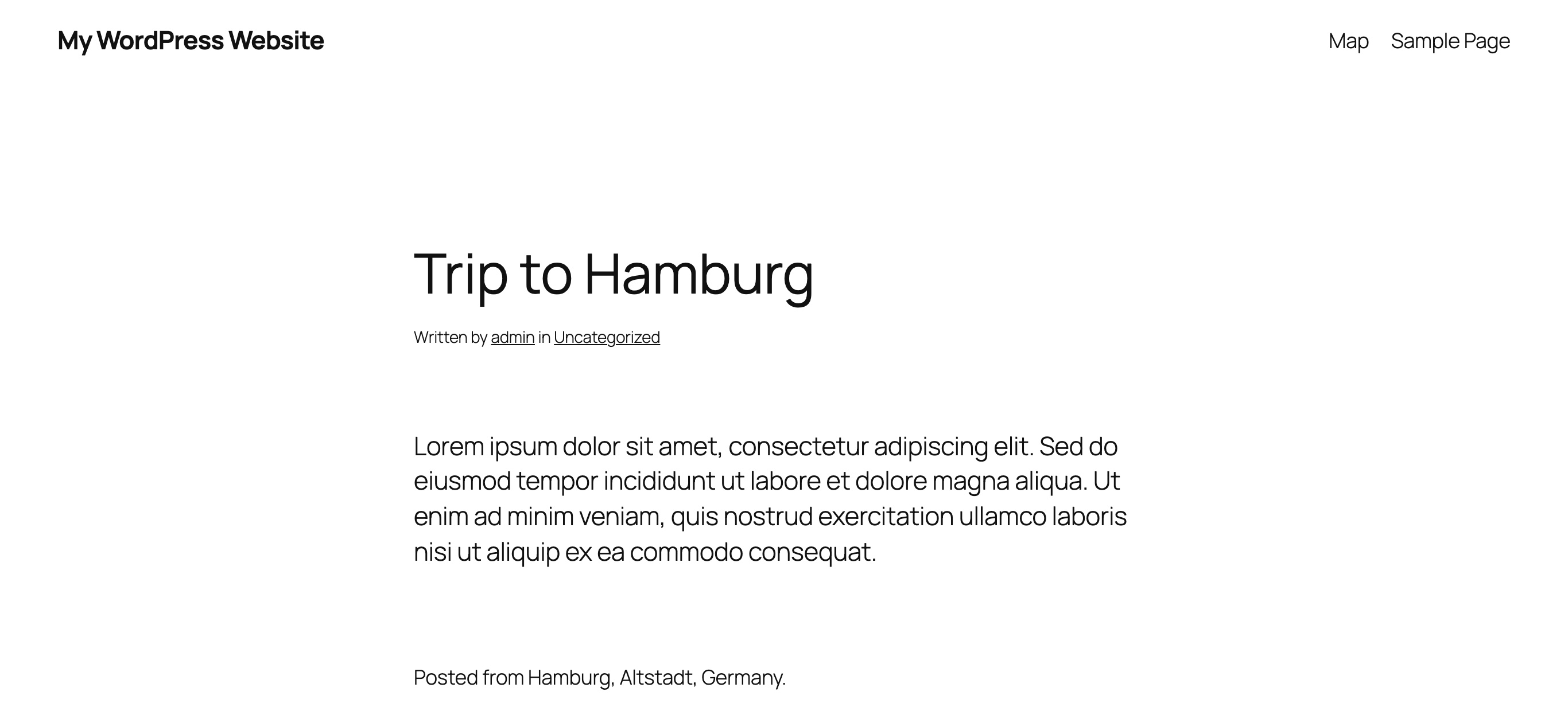
Put your stories on the map. Geolocation adds a location to your posts and shows it to your readers: as a line of text, as a link that reveals a map, or as a map. Collect your posts on an overview map, connect them to a route and add the GPX tracks of your hikes and bike tours.
Made for travel blogs, and for everyone who wants to show where a story happened. Maintained by Yann Michel since 2017.
Highlights
- A location for every post – search for an address, click on the map, drag the marker or use the position of your device. If a post has no location, the plugin reads it from the GPS data of the featured image.
- Three ways to show it – plain text, a link that reveals a map on hover, or a map. Before the post, after it, or exactly where you place the block.
- Overview maps – all posts of your blog, of a category or of a tag on one map. Popups show the featured image, the date and the excerpt; markers lying close together are grouped.
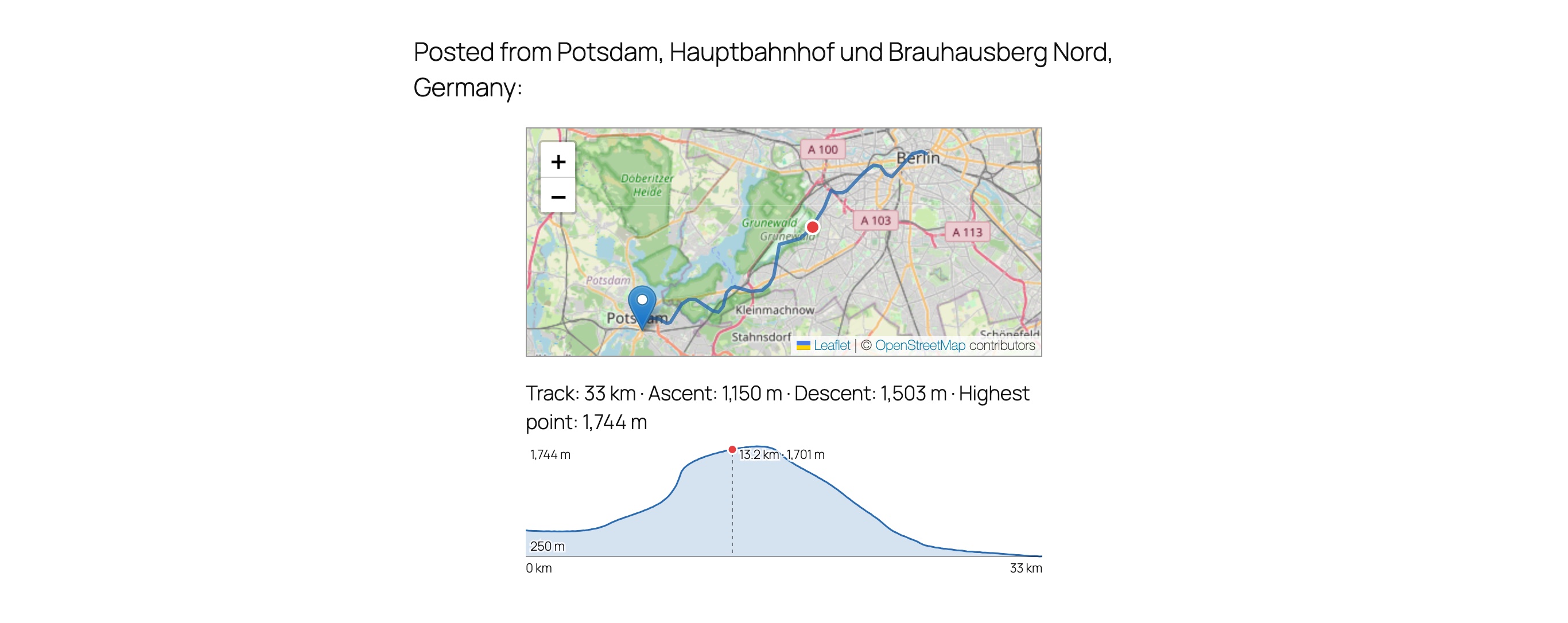
- Routes and GPX tracks – connect the posts of a trip in the order they were published, and show the recorded track of a hike or a bike tour with its length, ascent, descent and elevation profile.
- Blocks – two blocks with a live preview for the block editor: one for the location of a post, one for an overview map.
- Privacy by design – OpenStreetMap by default, map tiles from your own server, a strict mode that falls back to text, and GPX files that never leave your computer.
- OpenStreetMap – with an optional link that opens a location in the full map service.
- Translated – English, German, Spanish, French, Italian, Portuguese (Brazil) and Dutch.
Privacidade
The plugin uses OpenStreetMap by default and delivers the map library itself. Together with the proxy plugin for OSM the map tiles come from your own server, so the browsers of your visitors do not connect to an external map server.
- The strict privacy mode only shows maps if the tiles are delivered by the proxy. Otherwise visitors see the location as text.
- The strict privacy mode also covers the admin area: without the proxy the post editor and the settings page show no map, and addresses are looked up through your own server instead of by the browser of the author.
- The display mode plain text never loads a map for your visitors.
- Without the proxy, or with Google Maps, the tiles are loaded directly from the map service.
- The optional link to the external map requests nothing from the map service until a visitor follows it, and it does not tell the service which page the visitor comes from. A notice can be shown before the visitor leaves your website; in strict privacy mode it always is.
- With the proxy, the settings page can pre-cache the tiles of your maps, so the first visitor does not have to wait for them. It covers the first view of the map of every post and of every overview map, and works in small steps in the background; the tiles are also pre-cached automatically when a page or post is saved, unless you switch that off.
Locations from your photos
A post without a location takes it from the GPS data of its featured image. Two tips for photos taken with a phone:
- On an iPhone, take your photos as JPG. When a HEIC photo is converted for the upload, its GPS data is removed.
- In the WordPress app, enable the option to keep the metadata of uploaded files.
This also works for posts which are not created in the editor, e.g. by the WordPress app or through the REST API. Nobody has released such a location, so only logged-in users see it until you set it to public in the editor. With the setting “Featured image” these locations are public at once.
Posts which got their featured image before, without a location, can be caught up: in the settings, under “Featured image”, start reading the locations of existing posts once. It runs in the background, skips posts whose location you removed in the editor, and shows how many locations it found.
Google Mapas
The connection to Google Maps is no longer developed further: from version 1.19.0 on, new functions are made for OpenStreetMap only. New installations use OpenStreetMap; websites which already use Google Maps keep it with the functions it has today, as long as an API key is stored.
Google Maps needs an API key, which you get from the Google Cloud Platform. Activate the “Maps JavaScript API” and the “Geocoding API” for it.
Apoio
Questions, problems or ideas? Open a support request anytime, I am happy to help. If you like the plugin, a review is very welcome.
Overview maps on pages
Insert the block “Geolocation Map” into a page or a post to show a map with the locations of your posts. In the settings of the block you choose:
- the categories and tags whose posts are shown
- the width and the height of the map
- a fixed zoom level instead of fitting the map to the markers
- the route: a line which connects the locations in the order of the post dates. Combine it with a category to show the route of a single trip.
A page can contain several maps, and the editor shows each of them as a preview.
Tracks (GPX)
A post can carry the track of a GPX file, e.g. the recording of a hike or a bike tour. Choose the file in the Geolocation box of the post editor.
- The file is read in your browser. Only the simplified line of the track is stored with the post; the file itself, its times and elevations are not uploaded.
- With the display setting “Simple map” the map of the post shows the track; the map in the editor shows it as well.
- The post shows the key figures of the track: its length and, if the file contains elevations, ascent, descent and highest point. Below a map it also shows the elevation profile. Pointing at the profile, tapping it or moving along it with the arrow keys shows the distance and the elevation, and the map marks the same place of the track. Both can be switched off in the settings, and the block “Post Location” can show or hide them for a single post.
- An overview map with the option “route” draws the tracks as recorded and the gaps between them as dashed lines. The popup of a post shows the length of its track.
- A post without a location gets the end of its track as location.
- The setting “Shorten tracks” hides a distance at the start and at the end of every track, e.g. to keep your home address private.
Block “Post Location”
In a post the block “Post Location” shows the location of the post wherever you place it, as text, as link with a map on hover or as map with its own size. The editor shows a preview of the saved location. The automatic output before or after the post is omitted for posts using the block.
With the position setting “Not automatically” a location is only shown in posts containing the block. Such a post still appears on overview maps if its location is enabled and public.
Instalação
- Upload the
geolocationdirectory to the/wp-content/plugins/directory. (or simply install it from the official package repo) - Ative o plugin através do menu 'Plugins' em WordPress.
- Optionally: Install and activate the OSM proxy to make use of local delivery without tracking options for the source to your visitors.
- Modify the display settings as needed on the Settings > Geolocation page. The chosen settings can directly be seen in the OSM preview of the settings page.
- Start posting with geolocation data.
- Leave a rating on the plugin-page. 🙂
Log de Changes
Requires PHP 8.3 and WordPress 6.4. Google Maps is no longer developed further; websites which use it keep it.
1.20.0
- new: existing posts without a location can get the location of their featured image, read once in the background from the settings page.
- new: the settings page converts the shortcodes of existing pages and posts into the blocks, keeping their categories, tags, size, zoom and route.
- new: the elevation profile follows the pointer, a tap or the arrow keys, shows distance and elevation, and the map marks the same place of the track (OpenStreetMap).
- performance: overview maps load the featured images of their posts at once instead of one by one.
1.19.0
- PHP 8.3 and WordPress 6.4 or newer are required.
- Google Maps is no longer developed further and no longer offered to new installations. Websites which use it keep it, as long as an API key is stored, and see a notice about it in the admin area.
- fix: after “Remove location” the location is switched off and the editor no longer shows a marker at a default position.
1.18.0
- new: posts created by an app or through the API also get the location of their featured image; a setting decides whether such a location is public.
- new: the list of posts shows the location of every post, and editing several posts at once can publish their locations or take that back.
- fix: a location removed in the editor no longer comes back from the featured image when the post is saved again.
1.17.0
- performance: the map library (Leaflet or the Google Maps API) is only loaded once a map scrolls into view or a visitor points at a location link.
- performance: fewer database queries on websites whose settings have not been saved since an update.
1.16.0
- new: an optional link opens the location of a post in OpenStreetMap or Google Maps, depending on the selected provider.
- new: a notice can be shown before a visitor follows that link and leaves your website; in strict privacy mode it is always shown.
- fix: on narrow screens the map of a post is no longer wider than the screen with block themes.
1.15.1
- the strict privacy mode also covers the admin area: without the proxy the post editor and the settings page show no map, and addresses are looked up through your own server.
Capturas de tela



Para desenvolvedores
Este é o seu plugin? Mostre os números.
Adicione um crachá ao vivo ao seu site, Documentos ou Readme do GitHub. Ele é atualizado por conta própria - nenhuma conta necessária.
Best Geolocation alternatives
All gps plugins →



FAQ
Geolocation: quick answers
Respostas diretas, extraídas de dados ao vivo WordPress.org.
Fonte: WordPress.org
Is Geolocation free?
Yes. Geolocation is free to download and use from the official WordPress.org plugin directory.
Is Geolocation safe to use in 2026?
Geolocation is a solid plugin choice in 2026, with a few things worth checking first. It runs on 300+ sites, is rated 4.2/5 and was last updated 1 month ago, and scores 78/100 on our health check.
How many websites use Geolocation?
Geolocation is active on 300+ WordPress websites and has been downloaded 45,101 times since it launched in May 2010. It was downloaded 646 times in the last 30 days.
Does Geolocation work with WordPress 7.1?
Yes. The developer has tested Geolocation up to WordPress 7.1.5, the latest release. It requires WordPress 6.4 or newer.
What PHP version does Geolocation need?
Geolocation requires PHP 8.3 or higher. Most hosts run PHP 8.x today, so it works on any modern WordPress hosting.
When was Geolocation last updated?
The latest version, 1.20.0, was released on October 20, 2026 (1 month ago).
Who makes Geolocation?
Geolocation is developed and maintained by Chris.
What are the best alternatives to Geolocation?
The most popular alternatives to Geolocation are Trackserver (400+ installs), WP-Routes Plugin (100+ installs) and Geo2 Maps Add-on for NextGE… (80+ installs).
Alimentado por PageForge
Um modelo e uma planilha. Uma página real para cada pesquisa.
PageForge Transforma cada linha de um CSV em uma página WordPress com seu próprio título, URL, SEO campos e esquema, construído no layout que você já desenhou. Gratuito em WordPress.org.
- CSV e XLSX, mais Google Sheets em Profissional e Empresarial
- Seu próprio título, URL, SEO campos e esquema para cada página
- Funciona com o editor de blocos, Elementor, Divi e Avada
- Gratuito em WordPress.org, sem cartão de crédito