

WP GPX Maps – GPX, FIT & KML maps with elevation profile
Show your hikes, rides and runs from GPX, FIT, TCX or KML files on an interactive map with elevation profile, charts and route summary.

Sichere Auswahl
Yes — WP GPX Maps is a safe, well-maintained plugin to use in 2026. It runs on 4K+ sites, is rated 4.2/5 and was last updated 4 hours ago, and scores 89/100 on our health check.
- Aktiv entwickelt – letztes Update vor 4 Stunden
- Getestet mit dem neuesten WordPress (7.1)
- Momentum — downloads up 3894.3% vs the previous 30 days
Wie stapelt es sich?
Side-by-side bei Installationen, Updates, Bewertungen und Support


Tägliche Downloads
Download-Spitzen folgen normalerweise einer neuen Version - jede Website, die automatisch aktualisiert wird, gilt als Download.
Ranglisten
Where WP GPX Maps stands todayWordPress.org Ranglisten suchen
Live-Position in der Plugin-Suche, Top 100| Stichwort | Position |
|---|---|
| cycling | #3 |
| elevation profile | #1 |
| GPX | #1 |
| hiking | #3 |
| map | #29 |
Versionsübernahme
Anteil aktiver Sites pro Release.
Bewertungsaufschlüsselung
★★★★★★★★★★ 4.2 from 61 reviews
About WP GPX Maps
From the official readme · v1.15.00Beschreibung
WP GPX Maps turns a GPX, FIT, TCX or KML file into an interactive map and charts: upload the track, add the GPX Map block (or the [sgpx] shortcode) and your readers get the route, the elevation profile and the statistics of your hike, ride or run.
See how it works in under three minutes: the block, the shortcode, the charts, 3D maps and activities.
Fast, also with very long tracks
The map code is loaded only on the pages that show a map, and every map starts when it gets near the screen. Even long-distance trails open in a second or two. See them live:
- Camino Francés: 769 km, 32,962 points, a 2 MB GPX file
- Alta Via 1 of the Dolomites: 120 km, 7,441 points
- Alta Via degli Eroi on Monte Grappa: 40 km over the First World War front line
Maps
- OpenStreetMap and other free maps (no account needed): OpenStreetMap, OpenTopoMap, CyclOSM, Humanitarian, OpenSeaMap, and the Thunderforest maps (OpenCycleMap, Outdoors, Transport, Landscape) with a free Thunderforest API key.
- MapLibre (recommended), free and without an API key: vector maps (OpenFreeMap Liberty, Bright, Positron), OpenStreetMap and OpenTopoMap, 3D terrain, fog and sky, shaded relief and a tilted 3D view, or your own style (MapTiler, Stadia Maps…).
- MapBox with your own API key: Outdoors, Streets, Satellite, Satellite Streets, Light, Dark, Standard and custom styles, 3D terrain, fog and a tilted 3D view (
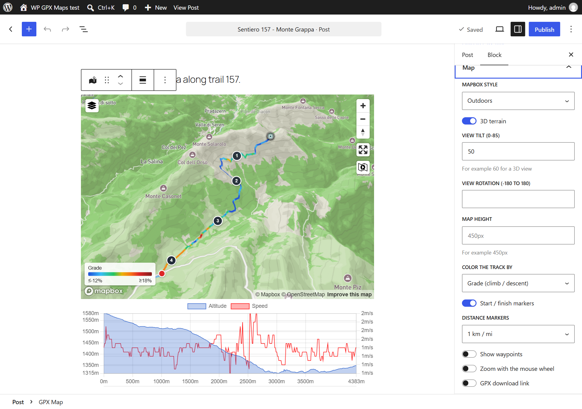
pitch,bearing). - Track colored by grade (blue descent, green flat, yellow to red climb), speed, heart rate or elevation, with a legend.
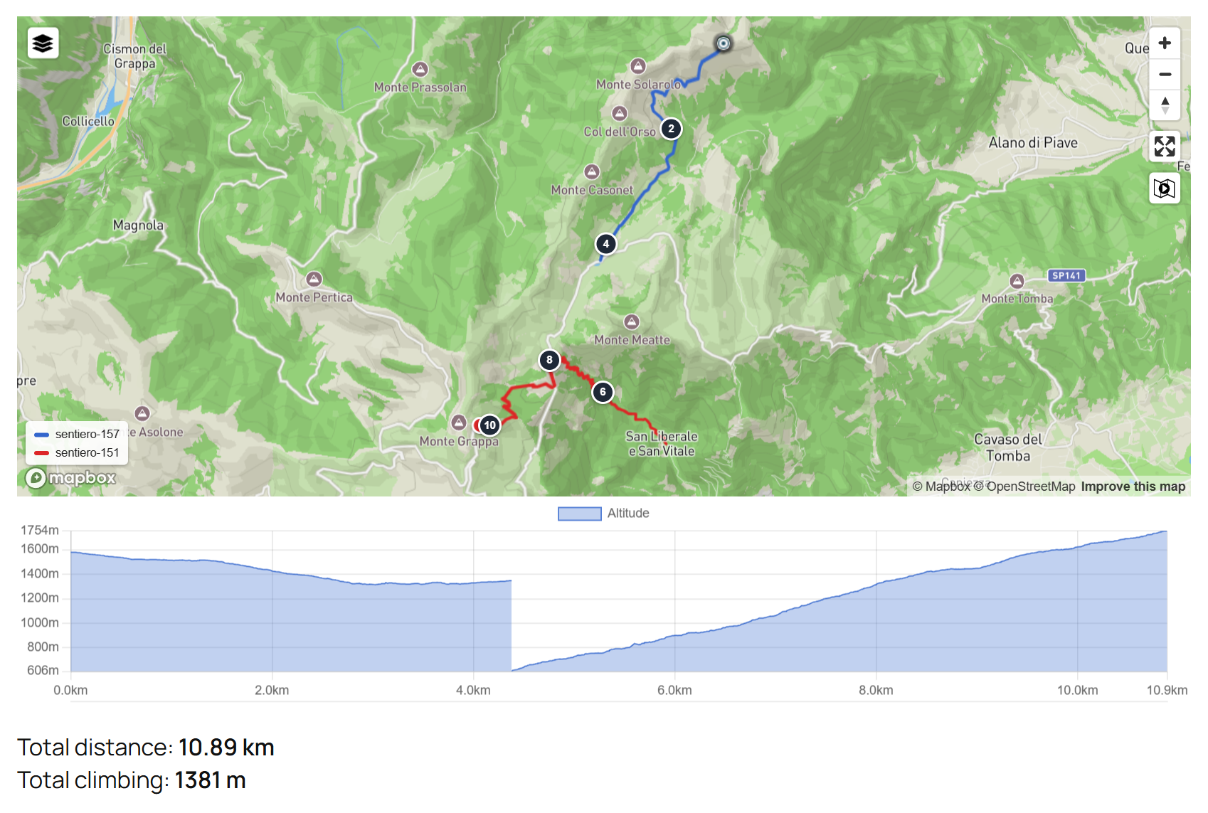
- Several GPX files in one map (
gpx="a.gpx,b.gpx"), one color per file with a legend. - Activities: tag your routes as hiking, stroller-friendly, mountain bike, climbing, snowshoeing and more (or your own activities, each with an emoji icon). Every activity has its own page on the site, and the site search finds routes by activity.
- Soft edges: the map can fade into the page instead of ending with a hard border (
fadeedges). - Start / finish markers, distance markers every N km or miles, waypoints with popups, full screen, photos from NextGEN Gallery or from the images attached to the post.
Charts
- Filled elevation profile, speed, heart rate, cadence, temperature and grade.
- Move the mouse on the chart and the position is shown on the map; move it on the track and the point is shown in the chart.
- GPS noise is smoothed out: grade averaged over about 100 m, speed without single spikes.
- Meters, kilometers, feet, miles or nautical miles; speed in km/h, mph, min/km, min/mile, knots or min/100 m.
Zusammenfassung
Total distance, maximum and minimum elevation, total climbing and descent, average and maximum speed, maximum grade, average heart rate, cadence and temperature, total time and moving time (pauses excluded).
Readable by AI assistants, search engines and screen readers
A map drawn by JavaScript is invisible to ChatGPT, Perplexity, Google AI Overviews and other AI assistants, to search engines and to screen readers: they read the text of the page, not the map. WP GPX Maps also describes every track in the page itself:
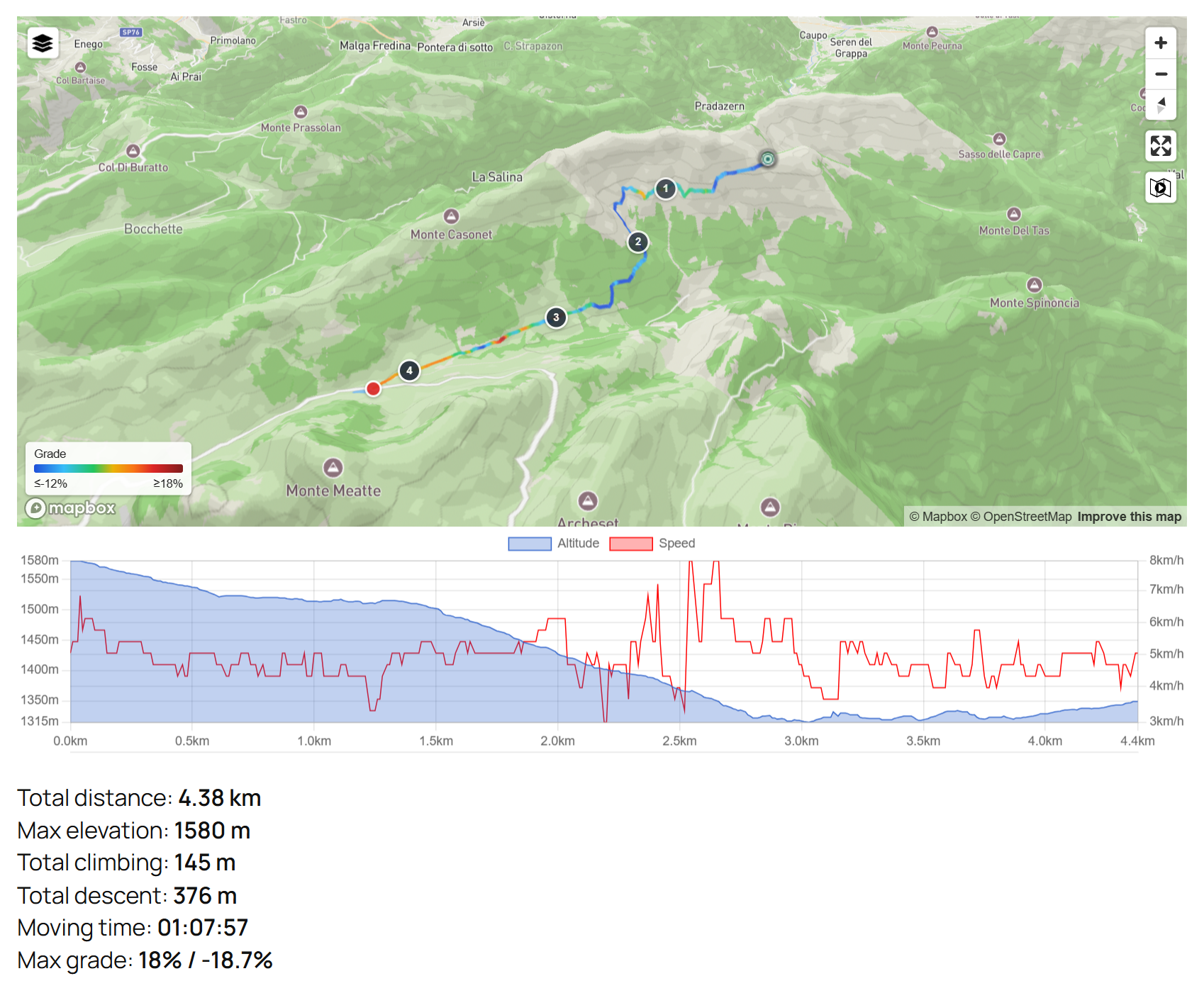
- Text description of the route, e.g. “Map of the route Sentiero 157: 4.38 km, 145 m of climbing and 376 m of descent, elevation between 1,315 m and 1,580 m, time 01:54:36. It starts at … and ends at …”, linked to the map for screen readers. Not shown on the page by default, or shown under the map (
description="visible"). - Structured data (schema.org
TouristTripin JSON-LD) with distance, climbing and descent, highest and lowest point, time, the line of the route, the start and finish and the waypoints shown on the map (each with its coordinates and a link to OpenStreetMap), so AI assistants and search engines can answer questions like “how long is this hike?” with the right numbers. The track file is linked only when you allow its download. - Both can be turned off in Settings > WP GPX Maps or for one map (
description="false",structureddata="false"), and changed by developers with thewpgpxmaps_track_descriptionandwpgpxmaps_structured_datafilters.
Easy to use
- GPX Map block for the block editor with live preview: pick an uploaded GPX file from a list and set every option in the sidebar.
- GPX Map widget for Elementor, with the same options and a live preview in the Elementor editor.
- Upload your track files in the Media Library, like images: they are organized by month, searchable and attached to the post. Or keep them in Settings > WP GPX Maps > Tracks (editors and authors can upload their own files).
- Every option has a default in the settings, so a simple
[sgpx gpx="/wp-content/uploads/gpx/my-track.gpx"]is enough. - GPX 1.0 and 1.1 (Garmin and Strava extensions: heart rate, cadence, temperature), FIT files from Garmin, Wahoo and other devices, TCX and KML / KMZ, multi-track files.
- Fast pages: the map style is loaded only on the pages with a map, and every map downloads its code only when it gets near the screen (lazy load). Cache of the processed tracks, works with PHP 7.4 to 8.4.
WP GPX Maps Pro (coming soon)
A separate add-on for sites whose readers go out on the routes. The free plugin keeps every feature: Pro adds new ones.
- Offline maps and navigation: readers save the route on the phone and follow it in the mountains without signal, with distance and climb left and an off-route warning.
- Stages planner: the route split in days that end at the huts along the way.
- Weather and sun along the route at the passage times, real sunrise and sunset.
- Story maps that follow the text as readers scroll, and a map of all your routes with filters by activity, distance and climb.
- Estimated times (CAI times for hiking), MTB difficulty, steep slopes for ski touring, an image for social media and more.
Compare Free and Pro, and get notified at launch with a launch discount.
Support and development
- Questions and bug reports: the support forum.
- Development, issues and pull requests: GitHub.
- Translations: translate.wordpress.org.
- Support the development: GitHub Sponsors.
Icons made by Freepik from www.flaticon.com, licensed under CC BY 3.0.
Installation
- Install the plugin from Plugins > Add New (search for “WP GPX Maps”) and activate it.
- Upload your GPX files in the Media Library (also from the block, with the Media Library button) or in Settings > WP GPX Maps > Tracks, or use any GPX file already on your site or on another site.
- In a post or page add the GPX Map block and choose the GPX file. With the classic editor use the shortcode, for example
[sgpx gpx="/wp-content/uploads/gpx/my-track.gpx"]. - Optional: in Settings > WP GPX Maps set the defaults for all the maps, a Thunderforest API key for the Thunderforest maps or a MapBox API key for the MapBox maps and 3D terrain.
Änderungsprotokoll
New GPX Map widget for Elementor, and complete Italian and German translations.
1.15.00
- New: GPX Map widget for Elementor, with the options of the block (file, map engine and style, colors, markers, charts, summary) and a live preview in the editor. Options left on “Plugin setting” use the values of Settings > WP GPX Maps
- New: complete Italian and German translations, and the missing French and Spanish strings, included with the plugin until the language packs of translate.wordpress.org are complete
- Fix: a map could start twice when an editor ran its script again (block editor before WordPress 6.3, Elementor)
1.14.03
- WP GPX Maps Pro is coming: a notice shown once to administrators, three days after the update (two buttons, both hide it for good), a closed “More with WP GPX Maps Pro” panel in the block sidebar and a section in this page. Nothing changes in the free plugin and nothing is shown when Pro is active
1.14.02
- Works again on WordPress 6.0 to 6.4: sites that could not update from 1.7 because of the WordPress 6.5 requirement can now update
- Fix: on WordPress versions before 6.3 the map preview of the block started twice in the editor and the chart showed an error
- Fix: after an update the block editor could keep using an old copy of the block script from the browser cache
1.14.01
- Security fix: the texts of waypoints and photos are now always escaped in the map popups of the Leaflet engine. Update recommended. Thanks to the security researcher who reported it responsibly
1.14.00
- Structured data: the route now also lists its start and finish (one place for a loop) and the waypoints shown on the map, in the order they are met along the way, each as a schema.org Place with its coordinates (and elevation for waypoints) and a link to the point on OpenStreetMap. Waypoints hidden on the map, for example in a WP GPX Maps Pro treasure hunt, stay out
- New FAQ: what structured data can and cannot do for search engines
1.13.04
- Fix: total climbing and descent were far too high on tracks with noisy GPS elevation, because every small up and down was added (a hike between 1,515 and 1,827 m showed 1,608 m of climbing). Changes under 5 meters are now ignored as noise, while real climbs are still counted whole: the same hike now shows 605 m. Tracks from planners and barometric devices change little (about 5% less). Developers can change the 5 meters with the new
wpgpxmaps_climb_thresholdfilter (0 gives the old numbers)
Screenshots



Für Entwickler
Ist das dein Plugin? Zeigen Sie die Zahlen.
Fügen Sie Ihrer Website, Docs oder GitHub Readme ein Live-Badge hinzu. Es wird von selbst aktualisiert - kein Konto erforderlich.
Best WP GPX Maps alternatives
All cycling plugins →

Fragen und Antworten
WP GPX Maps: quick answers
Gerade Antworten, gezogen von Live WordPress.org Daten.
Quelle: WordPress.org
Is WP GPX Maps free?
Yes. WP GPX Maps is free to download and use from the official WordPress.org plugin directory.
Is WP GPX Maps safe to use in 2026?
Yes — WP GPX Maps is a safe, well-maintained plugin to use in 2026. It runs on 4K+ sites, is rated 4.2/5 and was last updated 4 hours ago, and scores 89/100 on our health check.
How many websites use WP GPX Maps?
WP GPX Maps is active on 4K+ WordPress websites and has been downloaded 164,606 times since it launched in December 2011. It was downloaded 19,492 times in the last 30 days.
Does WP GPX Maps work with WordPress 7.1?
Yes. The developer has tested WP GPX Maps up to WordPress 7.1.5, the latest release. It requires WordPress 6.0 or newer.
What PHP version does WP GPX Maps need?
WP GPX Maps requires PHP 7.4 or higher. Most hosts run PHP 8.x today, so it works on any modern WordPress hosting.
When was WP GPX Maps last updated?
The latest version, 1.15.00, was released on November 20, 2026 (4 hours ago).
Who makes WP GPX Maps?
WP GPX Maps is developed and maintained by bastianonm.
What are the best alternatives to WP GPX Maps?
The most popular alternatives to WP GPX Maps are OS DataHub Maps (200+ installs), WP-Routes Plugin (100+ installs) and CycloPress (10+ installs).
Angetrieben von PageForge
Eine Vorlage und eine Tabelle. Eine echte Seite für jede Suche.
PageForge Verwandelt jede Zeile eines CSV in eine WordPress-Seite mit eigenem Titel, URL, SEO Felder und Schema entworfen. Kostenlos auf WordPress.org.
- CSV und XLSX, plus Google Sheets auf Beruf und Unternehmen
- seinen eigenen Titel, URL, SEO Felder und Schema für jede Seite
- Arbeitet mit dem Blockeditor, Elementor, Divi und Avada
- Kostenlos auf WordPress.org, keine Kreditkarte